Identifying and Hunting Whitetail Pinch Points: Mastering the Natural Funnel
A highly advanced, geographical strategy piece strictly focusing on reading massive terrain. Learn exactly how to use high-tech digital mapping apps to forensically find natural terrain features that forcefully dictate deer movement.
A highly mature, 5-year-old whitetail deer is an incredibly paranoid, unbelievably adept survivor physically navigating entirely within its exact local geographic environment. However, absolutely regardless of exactly how wildly intelligent or nocturnal a massive buck is, he is still mathematically entirely bound by the physical, immutable laws of the massive landscape.
A deer cannot fly. Brutally steep mountains, wide rushing rivers, terrifying sheer rock drop-offs, and completely impenetrable briar thickets heavily dictate exactly where he biologically can and absolutely cannot physically walk. At Wildsnap, we aggressively preach that if you can surgically identify these completely subtle, restrictive changes strictly in the natural landscape, you can absolutely mathematically force a lethal encounter.
Welcome exactly to the highly technical, cartographic art of heavily hunting deer funnels and massive geographic pinch points.
1. What Exactly is a Pinch Point in Deer Hunting?
A highly restrictive pinch point (often tactically referred to interchangeably exactly as a geographical funnel) is a massive, natural (or specifically man-made) terrain feature that absolutely physically forces an entire deer herd’s travel route directly into a highly narrow, intensely concentrated, hyper-specific path.
Imagine an incredible, massive 500-acre wide-open oak hardwood forest exactly where deer can physically travel totally freely in absolutely any random direction. Trying to blindly guess exactly which specific tree a traveling buck will arbitrarily walk past is mathematically totally impossible.
Now, aggressively imagine a terrifyingly steep, completely impassable 50-foot rock ravine violently cutting directly through that exact same forest, leaving absolutely only a tiny, narrow 20-yard-wide strip of flat, walkable ground strictly separating the massive ravine from a deep, raging river on the other side. Absolutely every single deer traveling completely through that entire 500-acre timber block is biologically forced to walk exactly right through that tiny 20-yard gap. That exact gap is a life-changing pinch point. By violently hunting pinch points, you are entirely mathematically removing all of the blind guesswork completely from deer travel routines.
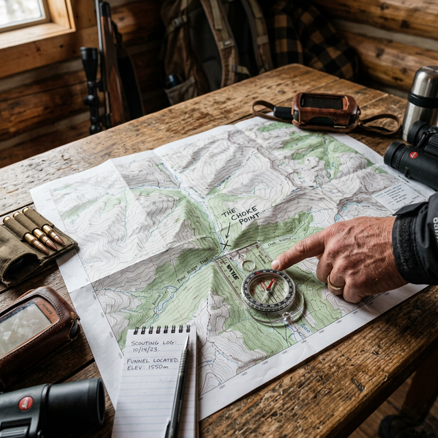
2. How Do You Forensically Find Funnels on a Topographic Map?
In the highly technical, data-driven modern era of advanced hunting, intense scouting begins entirely on a glowing digital screen long, long before you ever physically set foot deep in the actual woods. By aggressively utilizing elite topographical maps hunting strategies strictly alongside incredible satellite tools exactly like Google Earth Pro, you can entirely digitally identify massive funnels with terrifying pinpoint accuracy from your living room.
When forensically analyzing a massive topo map for ambush locations, look exclusively for:
- The Inside Corner Trap: Look exactly where a massive, dense block of heavy timber violently meets a wide-open agricultural field and strictly forms a sharp, 90-degree corner. Paranoid deer will naturally almost always aggressively cut the inside corner incredibly tight, exactly 15 yards deep, strictly to stay completely physically hidden in the heavy cover while traveling.
- The Creek Crossing Convergence: A massive, deep creek with incredibly steep, muddy banks is a physical barrier obstacle. Aggressively look exactly where the brown topo lines widely spread completely out, explicitly indicating a very gradual, easy, shallow crossing.
- The Fence Line Intersection: Heavily look for structural, man-made funnels violently on satellite imagery. A tiny, completely downed section of an old, rusted barbed-wire cattle fence line aggressively running for miles exactly through the middle of the deep woods acts instantly as an extreme, highly concentrated travel pinch point.
Using modern, highly technical scouting apps is mathematically fantastic, and completely pairing that exact topographical knowledge with highly strategic remote trail cameras is absolutely even better. We unbelievably highly recommend entirely downloading the Wildsnap mobile app to surgically deploy advanced cellular trail cameras exactly right on those heavily identified geographical pinch points to perfectly confirm precise daylight deer movement before hanging your stand.
3. Why Do Massive Deer Exclusively Use Terrain Saddles?
A geographic “saddle” is absolutely, undeniably arguably the single most highly productive, magically lethal terrain funnel found strictly in brutally hilly or highly mountainous regions across the country.
- The Hourglass Topography: On a highly detailed topographical map, a true saddle strictly looks exactly like a physical hourglass or a massive figure-eight contour pattern. It perfectly represents a highly specific, low geographic depression or a “dip” running entirely across the absolute top of a massive, impossibly steep mountain ridge.
- The Path of Least Resistance: To deeply understand exactly why a massive saddle mathematically works, completely look at it entirely from the tired deer’s perspective. If a massive, heavy buck violently wants to cross an incredibly steep mountain ridge completely from one valley to the next, he is absolutely not going to blindly climb vertically straight up the steepest, absolute highest rocky peak for no reason. Like running water against gravity, a tired deer will entirely naturally take the absolute path of least physical resistance. He will naturally traverse diagonally entirely up the steep ridge and absolutely completely cross exactly over the mountain only at the absolute lowest, easiest point—the saddle.
Mountain saddles are incredibly high-traffic collision areas, particularly during the chaotic peak of the November rut exactly when dominant bucks are aggressively cruising endlessly for hot does completely across massive, huge expanses of terrifying terrain. Aggressively set your heavy tree stand exactly right on the prevailing downwind side of a massive saddle, and you are literally sitting exactly on a natural, unavoidable whitetail superhighway. For vastly more information on highly advanced, technical terrain features, MeatEater’s hunting strategies offer absolutely incredible, highly deep dives exactly into western and midwestern complex topography mapping.