Hunting River Bottoms and Creek Crossings: A Masterclass in Riparian Zones
Massive waterways are the natural, undisputed super-highways of the whitetail world. Learn expert, high-level tactics to precisely identify traffic creek crossings, hunt alluvial oxbows, and play the complex thermals.
In massive, unbroken big-timber and mountainous continuous forest terrain, stark, dry topographical features like steep saddles and high rock ridges absolutely dictate all major deer movement. However, in heavily broken agricultural land or sprawling, deep Midwestern valleys, massive moving water is instantly the absolute defining, dictating feature of horizontal whitetail travel.
At Wildsnap, our most successful river-system hunters fundamentally refer to these critical, winding waterways as “The Riparian Interstates.” Massive river bottoms and creek-drainage systems organically offer the absolute ultimate whitetail trifecta: heavy, high-protein seasonal browse, incredibly dense, nasty security cover (often wildly too thick, wet, and miserable for casual human hunters to navigate), and powerful, highly predictable thermal wind currents.
To consistently harvest 5-year-old mature bucks in these intensely wet environments, you must surgically master the highly technical art of “alluvial-soil tracking” and deeply, biologically understand exactly how a mature animal uses complex water geography as a massive defensive shield.
1. The “Slack-Water” Intercept
It is a biological fact that whitetails are incredibly strong, buoyant swimmers. However, exactly like all wild prey animals deeply driven by winter survival, they are absolute masters of fierce caloric efficiency. They will absolutely not willingly, lazily cross a wide, freezing river where the deep current is boiling, nor will they pointlessly scramble up a violently vertical, heavily eroded 10-foot mud bank if they physically do not have to.
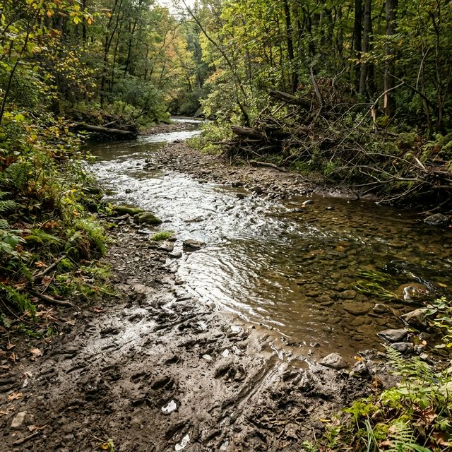
When aggressively scouting a massive river or tight creek system, you are not looking for deer; you are desperately looking for “efficiency hubs.”
- The “Bank Scars”: Vigorously walk or kayak the deep edges of the winding waterway actively looking for “bank scars”—highly specific, heavily eroded areas where the incredibly steep, sheer alluvial mud soil has been physically worn down by thousands of hooves over decades into a gentle, sloping ‘V’ shape entering the water. This is a definitive, multi-generational, massive traffic crossing point.
- The Hard-Bottom Pivot: Before ever hanging a tree stand, you absolutely must physically wade directly into the freezing water exactly at the bank scar. If the submerged crossing features a shallow, solid hard-rock or compacted gravel bottom (a “riffle”) rather than thigh-deep, sucking, treacherous mud, you have found an absolute primary travel hub. Deer physically despise deep, plunging mud that severely slows their rapid escape from heavy predators, so a single, solid hard-bottom crossing will literally geographically funnel every single deer from 2 miles up and down the winding river.
2. Bedding Strategies: The Oxbow Island Fortress
The oldest, most deeply mature bucks aggressively use massive geography as a weapon against predators. One of the absolute most perfectly defensible, naturally occurring geographic positions in the entire deer woods is an “oxbow” or a massive, ferociously sharp U-shaped river bend.
When a massive river bends that sharply, it often creates remarkably small, highly semi-isolated peninsulas or “dry islands” of high ground completely covered in impenetrable, thick green willows or towering canary grass.
- The Moat Defense Mechanism: A veteran, highly educated buck will explicitly bed directly on the absolute highest, driest point of this tiny peninsula with his back facing the massive, deep water of the river. He physically knows instinctively that absolutely no coyote, wolf, or human predator can possibly approach him from the deep water behind him without making a massive, catastrophic splashing racket.
- The Wind Advantage: He then spends the entire daylight sitting motionless, intensely staring directly back at his own narrow entrance trail leading onto the peninsula, perfectly allowing the prevailing cross-wind to aggressively carry the scent of the entire mainland directly into his nose. If you ever arrogantly attempt to directly stalk a buck in an oxbow bed, you will painfully lose 99.9% of the time. You absolutely must patiently wait for him to stand up and leave the bed in the evening, completely ambushing him on the dry transition trail far away from his fortress.
3. Mastering the Vicious Riparian Thermals
Hunting deep river bottoms is incredibly, famously frustrating to amateur hunters because the wind constantly, violently “swirls.” This is absolutely not random magic; it is due to highly complex physical thermal currents heavily caused by the massive water temperature differing drastically from the ambient air temperature, hugely compounded by the steep, plunging walls of the river valley.
The Golden Physics Rule of Thermals: Warm air fiercely rises, freezing cold air rapidly drops.
- The Morning Thermal Rise (The Vacuum): As the morning sun physically rises and begins to heavily heat the high ridges directly above the river, the rapidly warming air powerfully pulls straight up the steep valley walls, violently carrying your human scent completely out of the dark bottom. Morning hunts in a river bottom are highly, ruthlessly effective if you are set up extremely high on the steep bank.
- The Evening Death Trap: As the sun fiercely sets, the ambient air rapidly, aggressively cools and instantly becomes incredibly heavy. This cold air violently “drops” completely off the high ridges and plummets directly into the absolute lowest topographical point of the entire geography—the river channel itself. If you stubbornly sit directly on the water’s level edge in the late afternoon, your heavy human scent will be violently sucked directly into the massive water channel and powerfully carried downstream for miles like a visible, invisible fog, completely spooking every single mature deer within a half-mile radius.
- The Solution: For any evening sit, you absolutely must position your tree stand slightly above the main travel corridor, radically off the immediate bank level, to stay completely, surgically out of this descending, violently pooling thermal river of air.
RIVER SAFETY: Violent Flash Floods and Catastrophic Bank Collapse
Deep river bottoms are incredibly highly dynamic, wildly unpredictable, and violently physically dangerous geographic environments.
- The Flash Flood Threat: Strictly depending on the geographical topography, a massive, severe rainstorm occurring 15 miles upstream can violently turn a quiet, ankle-deep 4-foot creek into a raging, terrifying 12-foot torrent of heavy, debris-filled destruction in a matter of literally 30 minutes. Always obsessively check the highly detailed weather radar forecast for the entire massive upstream drainage basin, not just the local sunny zip code where your truck is currently parked.
- The Bank Erosion Hazard: Deep alluvial soil (the massive amounts of silt and soft sand heavily deposited by rapid water) is inherently, structurally unstable. We have treated hunters seriously injured by lazily walking too close to the steep edge of an undercut “cut-bank” or heavily leaning a massive metal climbing stand against a tall tree growing on a completely eroded, soft edge, leading to a massive, catastrophic mud collapse directly into the freezing river. Always meticulously inspect the exposed root system of your chosen anchor tree, and absolutely never hunt a steep, 15-foot mud bank without securely wearing a modern, ANSI-rated full fall-arrest safety system tightly tethered to the trunk.
Fiercely follow the deep water, mathematically respect the wildly shifting thermal winds, and obsessively understand the alluvial mud. If you aggressively learn to accurately read a complex river system, you will rapidly find the absolute giant bucks that spend their entire ghost-like lives hiding completely un-hunted in the impenetrable, flooded willows.